News Summary
The National Weather Service has issued a Severe Thunderstorm Warning for Greenville and Spartanburg counties. The storms could bring high wind gusts and hail, urging residents to take necessary precautions. Doppler radar indicates significant thunderstorms approaching, with a risk of damaging winds and lightning. The NWS recommends seeking shelter and monitoring updates as storm conditions are expected to persist throughout the evening.
Severe Thunderstorm Warning Issued for Greenville and Spartanburg Counties
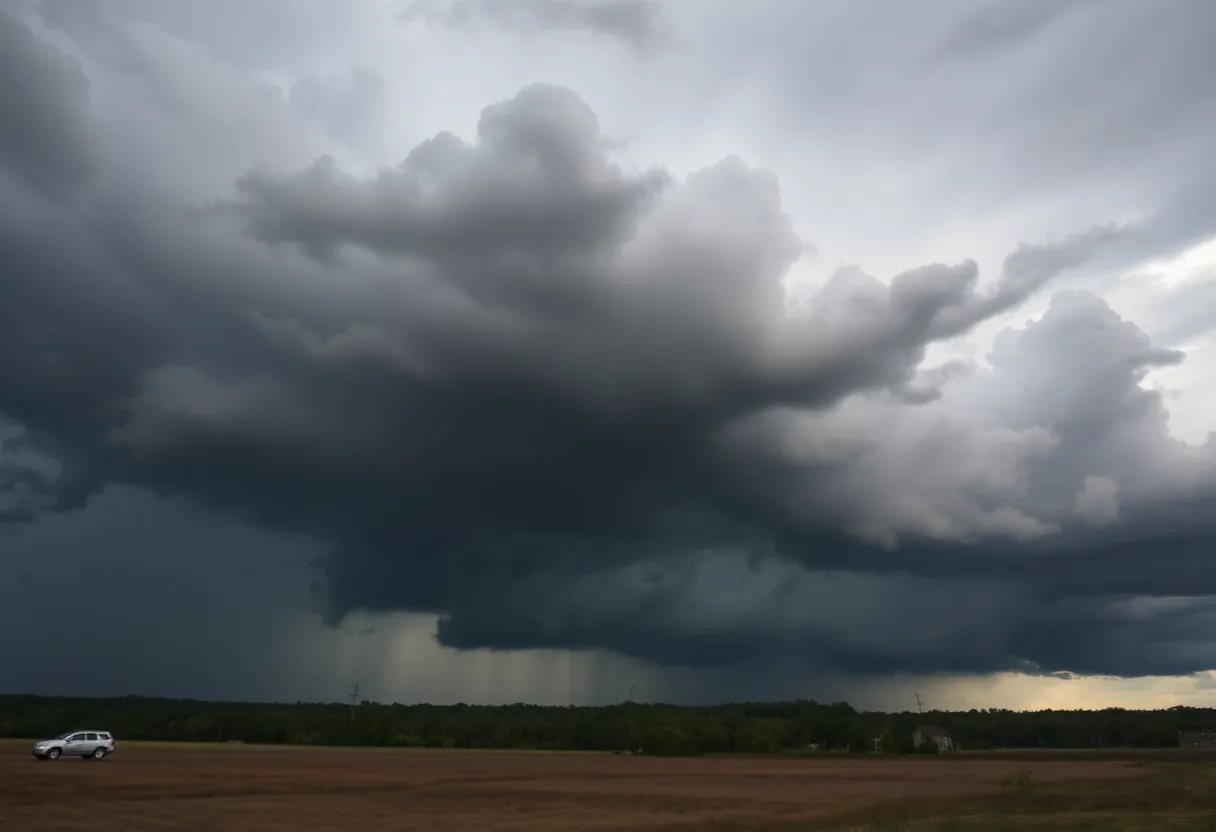
Greenville, SC – The National Weather Service (NWS) has issued a Severe Thunderstorm Warning for Greenville and Spartanburg counties, effective until 10 p.m. on Friday night. This warning was released at 9:23 p.m. as strong thunderstorms with the potential for hazardous weather approached the area, bringing high wind gusts and hail.
Doppler radar indicated that a significant thunderstorm was located 4 miles northwest of Columbus, moving east at a speed of 25 mph. Wind gusts associated with the storm are projected to reach speeds of up to 40 mph, while hail could range from marble-sized (approximately 0.5 inches) to an inch in diameter.
Impact and Precautions
Residents in the affected areas, which include Columbus, Flat Rock, Landrum, Tryon, Saluda, Pleasant Ridge State Park, Jones Gap State Park, Caesars Head State Park, Dupont State Forest, and Mill Spring, are advised to take precautions. The potential impacts of these storms include:
- Knocked-down tree limbs
- Unsecured objects being blown around
- Minor damage to outdoor items due to hail
As frequent cloud-to-ground lightning is a characteristic of these storms, the NWS encourages those outdoors to seek shelter in a building. Lightning can strike as far as 10 miles from the storm, posing a significant risk. On average, there are about 25 million lightning strikes across the U.S. annually, which result in approximately 20 fatalities each year.
Weather Conditions and Expectations
Meteorologist reports suggest that significant weather events may persist between 6 p.m. and midnight in Greenville, Spartanburg, and Anderson. An 80% chance of showers and thunderstorms has been predicted, with wind gusts potentially exceeding 58 mph at times. Additionally, a raised threat level from one to two has been issued, indicating the organized nature of these storms.
Factors contributing to the severe weather conditions include an upper disturbance in the atmosphere, leading to a likelihood of isolated thunderstorms continuing into the night. While the chance of precipitation is expected to diminish overnight to 40%, there remains a 70% chance of thunderstorms following the initial warning.
Residents are also reminded to ensure the safety of their pets during this storm period, as they should be brought indoors if outdoors.
Future Weather Outlook
Looking ahead, preconditions on May 9 indicate a 50% chance of precipitation, although a reduced likelihood of hail is forecasted. Conditions are expected to improve over the weekend, with minimal precipitation chances at 30% reported for May 10. However, weather patterns may shift again on May 11, leading to an increase in rain chances up to 40%.
Context of Severe Thunderstorm Alerts
This is not the first severe thunderstorm warning issued for the area. A previous warning was recorded on June 1, highlighting similar threats including wind gusts of up to 60 mph and hail reaching up to 1 inch. During that prior warning, locations affected included Reidville, Five Forks, Lake Robinson, and several others in the region.
The NWS emphasizes the importance of seeking shelter in an interior room on the lowest floor of a building during severe weather. Citizens are encouraged to report damages such as winds, hail, or flooding through designated reporting channels to ensure an accurate assessment of storm impacts.
Deeper Dive: News & Info About This Topic
HERE Resources
Wofford College Hosts Civil Discourse Event
Severe Thunderstorm Warning Issued for Upstate South Carolina
Severe Thunderstorm Warning Issued for Greenville and Spartanburg
Multiple Crashes Cause Major Traffic Delays on I-85 in Spartanburg County
Wofford College President Nayef Samhat to Step Down
Wofford College Achieves Outstanding APR Results
Wofford College President Nayef Samhat to Step Down
Severe Thunderstorm Warning Issued for Cherokee and Spartanburg Counties
Brush Fires Prompt Evacuations in North and South Carolina
Severe Thunderstorm Warning Issued for Spartanburg and Cherokee Counties
Additional Resources
- Greenville Online: Weather Forecast Update
- Wikipedia: Severe Thunderstorm
- Fox Carolina: Winter Weather Update
- Google Search: Severe Weather Alert
- Island Packet: Weather News
- Google Scholar: Thunderstorm Safety
- Herald Online: Weather News
- Encyclopedia Britannica: Weather Warnings
- Weather.com: Spartanburg Weather
- Google News: Thunderstorm Warnings

Author: STAFF HERE SPARTANBURG
The SPARTANBURG STAFF WRITER represents the experienced team at HERESpartanburg.com, your go-to source for actionable local news and information in Spartanburg, Spartanburg County, and beyond. Specializing in "news you can use," we cover essential topics like product reviews for personal and business needs, local business directories, politics, real estate trends, neighborhood insights, and state news affecting the area—with deep expertise drawn from years of dedicated reporting and strong community input, including local press releases and business updates. We deliver top reporting on high-value events such as the Spartanburg International Festival, Spartanburg ArtWalk, and motorsport events at Spartanburg Speedway. Our coverage extends to key organizations like the Spartanburg Area Chamber of Commerce and the Spartanburg Regional Healthcare System Foundation, plus leading businesses in manufacturing and textiles that power the local economy such as BMW Manufacturing and Milliken & Company. As part of the broader HERE network, including HEREAiken.com, HEREBeaufort.com, HEREChapin.com, HERECharleston.com, HEREClinton.com, HEREColumbia.com, HEREGeorgetown.com, HEREGreenwood.com, HEREGreenville.com, HEREHiltonHead.com, HEREIrmo.com, HEREMyrtleBeach.com, HERENewberry.com, HERERockHill.com, and HERESpartanburg.com, we provide comprehensive, credible insights into South Carolina's dynamic landscape.