News Summary
The National Weather Service has issued a severe thunderstorm warning for Cherokee and Spartanburg counties until 8:45 PM. A powerful thunderstorm, detected near Mayo, could produce marble-sized hail and winds up to 55 mph. Residents are advised to seek shelter indoors due to risks of lightning and potential hail damage. Additionally, the warning highlights hydroplaning risks for drivers in wet conditions. Communities impacted include Cowpens, Mayo, Chesnee, and the historic Cowpens National Battlefield.
Gaffney, SC: Severe Thunderstorm Warning Issued for Cherokee and Spartanburg Counties
The National Weather Service (NWS) has issued a Severe Thunderstorm Warning for Cherokee and Spartanburg counties, effective until 8:45 PM on Sunday. This warning comes as strong thunderstorms have been identified in the area, posing hazards to residents and travelers.
As of the latest update at 8:13 PM, Doppler radar detected a powerful thunderstorm located 9 miles west of Gaffney, specifically near Mayo. This storm is reported to be stationary and is capable of producing marble-sized hail measuring up to 0.5 inches in diameter, along with wind gusts reaching speeds of up to 55 mph.
The NWS cautions that these gusty winds have the potential to knock down tree limbs and scatter unsecured outdoor objects. Minor hail damage may also occur to vehicles and other outdoor possessions in the path of the storm. The communities of Cowpens, Mayo, Chesnee, and the historic Cowpens National Battlefield are among the locations directly affected by this warning.
Safety Recommendations and Thunderstorm Hazards
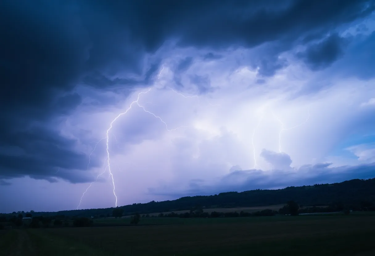
Given the prevalence of frequent cloud-to-ground lightning accompanying the storm, the NWS urges individuals who are outside to seek shelter indoors. It is crucial to recognize that lightning can strike up to 10 miles away from a thunderstorm. Each year, there are approximately 25 million lightning strikes in the United States, predominantly occurring during the summer months. On average, these strikes result in about 20 fatalities annually.
The risk of lightning strikes heightens as a thunderstorm approaches, reaches its peak when the storm is directly overhead, and diminishes as the storm retreats. For personal safety, those in affected areas are encouraged to stay indoors until the storm passes.
Understanding Hydroplaning Risks
In addition to lightning and high winds, the thunderstorm may produce conditions leading to hydroplaning on roadways. Hydroplaning occurs when a vehicle slides uncontrollably on wet surfaces, primarily due to water accumulating in front of the tires. This dangerous situation can arise when water pressure forces a vehicle to rise on a thin layer of water, resulting in a loss of traction with the road.
The NWS outlines three primary causes of hydroplaning and recommends that drivers reduce speed in wet conditions and avoid sudden movements to maintain control of their vehicles. If a driver finds themselves hydroplaning, it is vital to stay calm, refrain from slamming on the brakes, and steer in the direction they want the front of the vehicle to go.
Conclusion
As Cherokee and Spartanburg counties prepare for the severe thunderstorm, residents are advised to stay informed of weather developments and heed all safety recommendations provided by the NWS. Taking precautions can mitigate risks associated with thunderstorms and protect individuals and property during this hazardous weather event.
Deeper Dive: News & Info About This Topic
HERE Resources
Severe Thunderstorm Alert Issued for Greenville and Spartanburg
Devastating Tornado Outbreak in North Dakota Claims Three Lives
Severe Thunderstorm Warning Issued for Cherokee and Spartanburg Counties
Cherokee and Spartanburg Counties Face Severe Thunderstorm Warning
Severe Thunderstorm Warning Issued for Greenville and Spartanburg
Severe Thunderstorm Alert Issued for Spartanburg County
Severe Weather Action in Texas as Emergency Resources Mobilized
Severe Thunderstorm Warning for Greenville and Spartanburg
Wofford College Hosts Civil Discourse Event
Severe Thunderstorm Warning Issued for Upstate South Carolina
Additional Resources
- KOAM News
- Google Search: Severe Thunderstorm Warning
- Greenville Online
- Wikipedia: Thunderstorm
- New York Times
- Encyclopedia Britannica: Thunderstorm
- Fox 14 News
- Google News: Thunderstorm Safety Precautions

Author: STAFF HERE SPARTANBURG
The SPARTANBURG STAFF WRITER represents the experienced team at HERESpartanburg.com, your go-to source for actionable local news and information in Spartanburg, Spartanburg County, and beyond. Specializing in "news you can use," we cover essential topics like product reviews for personal and business needs, local business directories, politics, real estate trends, neighborhood insights, and state news affecting the area—with deep expertise drawn from years of dedicated reporting and strong community input, including local press releases and business updates. We deliver top reporting on high-value events such as the Spartanburg International Festival, Spartanburg ArtWalk, and motorsport events at Spartanburg Speedway. Our coverage extends to key organizations like the Spartanburg Area Chamber of Commerce and the Spartanburg Regional Healthcare System Foundation, plus leading businesses in manufacturing and textiles that power the local economy such as BMW Manufacturing and Milliken & Company. As part of the broader HERE network, including HEREAiken.com, HEREBeaufort.com, HEREChapin.com, HERECharleston.com, HEREClinton.com, HEREColumbia.com, HEREGeorgetown.com, HEREGreenwood.com, HEREGreenville.com, HEREHiltonHead.com, HEREIrmo.com, HEREMyrtleBeach.com, HERENewberry.com, HERERockHill.com, and HERESpartanburg.com, we provide comprehensive, credible insights into South Carolina's dynamic landscape.