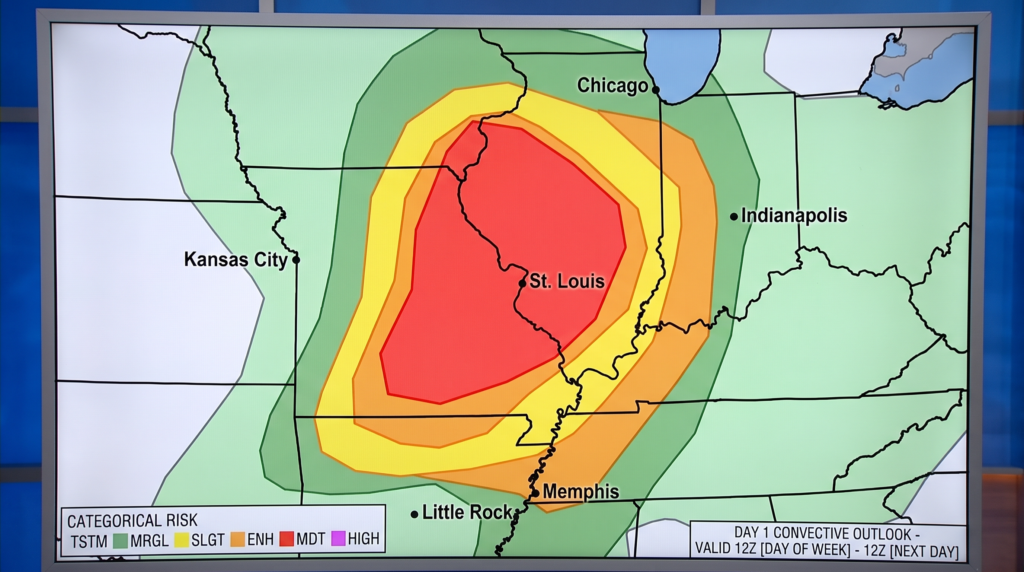
The Storm Prediction Center elevated the St. Louis region to a Level 4 out of 5 — Moderate Risk — for severe thunderstorms on Monday, April 27, 2026. The National Weather Service office in St. Louis set the primary danger window from 2:00 PM through 10:00 PM CDT, with hazards including baseball-sized hail, damaging winds, and tornadoes rated EF2 or stronger. The threat corridor placed more than 60 million people at risk from southern Minnesota through Arkansas and into northern Alabama.
Missouri counties inside the Level 4 zone included St. Louis City, St. Louis County, St. Charles County, Jefferson County, Franklin County, Lincoln County, Pike County, and Warren County. Illinois counties covered Madison, St. Clair, Monroe, Bond, and Clinton. A “Particularly Dangerous Situation” tornado watch — a designation reserved for the highest-confidence outbreak scenarios — was issued for part of the region. NWS St. Louis meteorologist Brian Hays urged anyone under a tornado warning to move immediately to an interior room or basement.
The large-scale pattern — a powerful upper-level shortwave trough pressing into a deeply unstable warm sector — is the same atmospheric setup that can push severe weather east toward the Carolinas. The NWS Greenville-Spartanburg forecast office, based at GSP International Airport in Greer, tracks Plains-to-East convective patterns for downstream impacts across Upstate South Carolina. When a major Midwest outbreak unfolds, that same trough typically sweeps the Southeast within days.
Upstate South Carolina carries direct experience with this kind of event. On April 13, 2020, the final night of the Easter tornado outbreak drove EF3 tornadoes through the Upstate before dawn. One track ran more than 16 miles through Oconee and Pickens counties, killing one person near Seneca and causing more than $100 million in damage. Twenty-six tornadoes were confirmed across South Carolina that morning. Spartanburg County’s Office of Emergency Management coordinates with NWS Greenville-Spartanburg when systems approach from the west, and the SC Forestry Commission monitors post-frontal winds that can elevate wildfire risk in a storm’s aftermath.